CHENEY, Wash. — Evacuations have been ordered for the Columbia Basin Fire.
UPDATE: July 26, 4:00 p.m.
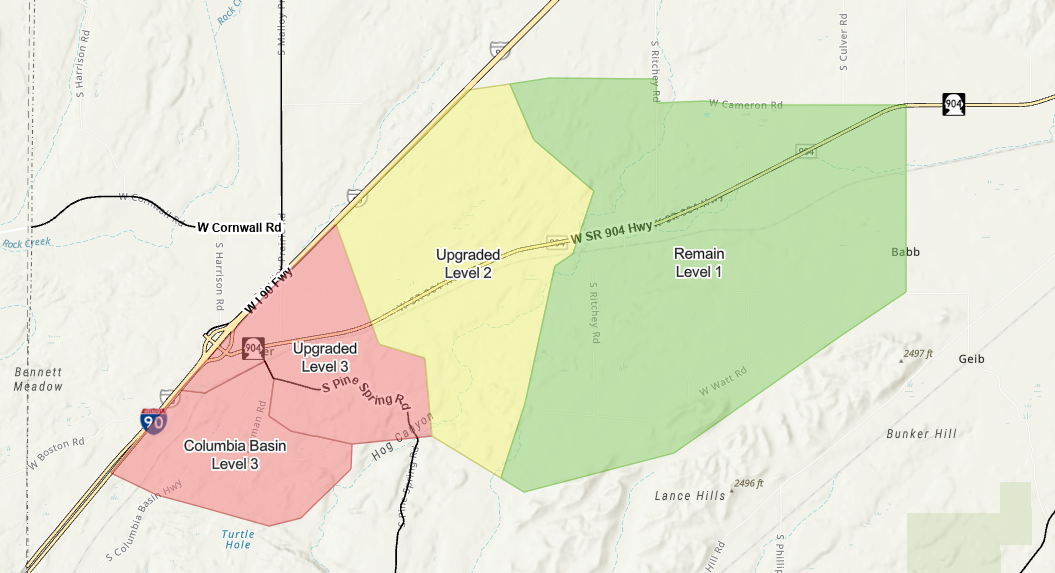
Spokane County Emergency Management said the Level 2 evacuation area for the Columbia Basin Fire is now at Level 3 (Go Now) evacuations. The Level 1 evacuation area is now at Level 2.
The American Red Cross is setting up an evacuation shelter at Cheney High School for those impacted by the fire.
Updated at 3:32 p.m.
Level 3 (GO NOW) evacuations for residents living in Columbia Basin Highway between 25610 S Columbia Basin Highway and Pine Spring Rd and Carmen Rd south of Pine Spring Rd, must leave now due to the life-threatening conditions in your area!
Level 2 (Get Set) evacuation residents living between the community of Tyler and 26022 W SR 904, on Pine Spring Rd between 24914 S Pine Spring Rd and Tyler, and the community of Tyler,
Level 1 (Get Ready) evacuations residents living north and east of the community of Tyler, should prepare to leave your current location. Conditions could get worse due to the Wildland Fire.
Spokane County Fire District 3 brought in firefighting equipment as smoke billowed into the sky Friday afternoon around 2:00 p.m. along Columbia Basin Hwy.
Washington State DNR Wildfire crews are responding to the Columbia Basin Fire. Fire is estimated at 50 acres with ground crews and aircraft assigned.
According to Spokane County Fire District 9, dozer 9 has been requested to assist on the Colombia Basin Fire.
Monitor phone and media for more info or visit https://bit.ly/SRECOfficialEvac for current evacuation maps
Level 1 (Get Ready) evacuations, meaning start preparing to leave, were issued for those living or working along I-90, southeast to Watt Rd., and north up to Ritchy Rd. and Cameron Rd.
Level 2 (Get Set) evacuations, meaning a mandatory evacuation could come anytime, so it’s time to urgently prepare, was issued along I-90 southeast to Hog Canyon (Pine Spring Rd.).
Level 3 (Go Now) evacuations, meaning GET OUT NOW, were issued for Carmen Rd. south to Turtle Hole.
SREC Spokane has an interactive map of evacuations.
COPYRIGHT 2024 BY KXLY. ALL RIGHTS RESERVED. THIS MATERIAL MAY NOT BE PUBLISHED, BROADCAST, REWRITTEN OR REDISTRIBUTED.